
Flooding risk rises across Fraser Valley and North Shore as heavy rain moves into B.C.
Emma MacLeod
12/15/20252 min read

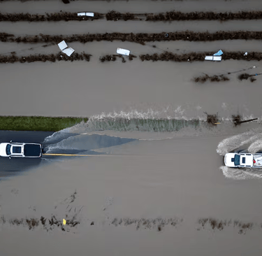
Flooding is expected in parts of British Columbia’s Fraser Valley and North Shore Mountains as another wave of heavy rain moves through already saturated regions.
Thousands of homes were without power across the Lower Mainland on Monday morning as strong winds and intense rainfall continued. Environment Canada has issued orange-level rainfall warnings for parts of the west and central Fraser Valley, including Abbotsford and Chilliwack, as well as the Skagit Valley. Forecasters say up to 80 millimetres of rain could fall in higher elevations.
Orange warnings indicate severe weather that could cause significant damage or disruption. Yellow-level rainfall warnings — signaling hazardous but less severe conditions — are also in effect for Metro Vancouver, the Sea-to-Sky corridor, Vancouver Island, and B.C.’s central and north coast. The heaviest rain is expected during the day Monday, tapering off in the evening.
Rivers rising rapidly
The B.C. River Forecast Centre has upgraded the Chilliwack River and its tributaries to a flood warning, meaning river levels have exceeded or are expected to exceed their banks, causing flooding in nearby areas. A similar flood warning is now in place for the North Shore Mountains.
Officials say rainfall rates above 10 millimetres per hour, combined with above-freezing temperatures melting snowpack at higher elevations, are driving rapid increases in river levels. The Seymour River has already reached a 50-year flow level, prompting warnings that flooding near riverbanks is likely.
Flood watches are also in place for tributaries of the lower Fraser River, including areas around Pemberton and the Fraser Canyon, as well as the Kingcome and Englishman rivers. High streamflow advisories remain in effect across much of the coast, Vancouver Island, Haida Gwaii and parts of the Interior.
A flood warning remains active for the Sumas River, though modelling suggests a lower chance of overflow from Washington state’s Nooksack River, which contributed to recent flooding in Abbotsford.
Provincial officials say this storm system is expected to be weaker than the previous one, but uncertainty remains, especially for areas that were recently flooded.
Power outages and transportation impacts
B.C. Hydro reports thousands of customers lost power due to storm-related outages. On the North Shore, roughly 16,000 customers were affected after high winds brought down a wire, though power was restored later in the morning. In the Fraser Valley, more than 8,000 customers across Surrey, Richmond and Langley were still without electricity as crews worked to restore service.
Emergency officials warn flood and landslide risks could increase as the storm progresses. While some road conditions have improved, they may deteriorate quickly if water levels rise.
In Abbotsford, receding floodwaters allowed many evacuation orders to be downgraded over the weekend. However, dozens of properties remain under evacuation order, with hundreds more still on alert, particularly in the Sumas Prairie. Provincial officials say dozens of farms remain affected, with damage reported to barns and livestock operations.
The Ministry of Transportation has cautioned drivers to expect sudden highway closures due to the risk of rockfall, debris flows and washouts. As a precaution, major routes including Highway 1 through the Fraser Canyon and Highway 99 between Pemberton and Lillooet remain closed.
Drivers are being urged to avoid flooded roads, expect delays and closely monitor conditions as the weather system moves through the region.
News
Stay updated with the latest BC news stories, subscribe to our newsletter today.
SUBSCRIBE
© 2026 Innovatory Labs Inc. All rights reserved.
LINKS